Showing 867 results
Archivistische beschrijving431 results with digital objects Show results with digital objects
UKLSE_DL1_CB01_004_001_0029_0001.jpg
UKLSE_DL1_CB01_004_001_0034_0001.jpg
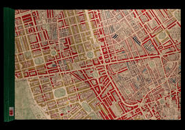
BOOTH/E/2/35-Hand Coloured Map Descriptive of London Poverty 1898-1899 Sheet 74 - Kensington, Hyde Park, Kensington Gardens, [Knight's Bridge]
BOOTH/E/2/35-Hand Coloured Map Descriptive of London Poverty 1898-1899 Sheet 74 - Kensington, Hyde Park, Kensington Gardens, [Knight's Bridge]
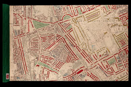
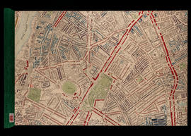
BOOTH/E/2/39-Hand Coloured Map Descriptive of London Poverty 1898-1899 Sheet 78 - Rotherhithe, Southwark, Isle of Dogs (part)
BOOTH/E/2/39-Hand Coloured Map Descriptive of London Poverty 1898-1899 Sheet 78 - Rotherhithe, Southwark, Isle of Dogs (part)
UKLSE_DL1_CB01_004_001_0039_0001.jpg
UKLSE_DL1_CB01_004_001_0043_0001.jpg
UKLSE_DL1_CB01_004_001_0044_0001.jpg
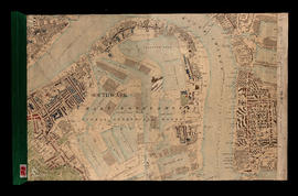
BOOTH/E/2/47-Hand Coloured Map Descriptive of London Poverty 1898-1899 Sheet 92 - Millwall, Greenwich, Maze Hill
BOOTH/E/2/47-Hand Coloured Map Descriptive of London Poverty 1898-1899 Sheet 92 - Millwall, Greenwich, Maze Hill
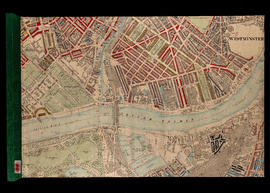
BOOTH/E/2/49-Hand Coloured Map Descriptive of London Poverty 1898-1899 Sheet 100 - Fulham, Sands End, Battersea, Battersea Park (part)
BOOTH/E/2/49-Hand Coloured Map Descriptive of London Poverty 1898-1899 Sheet 100 - Fulham, Sands End, Battersea, Battersea Park (part)
BOOTH/E/2/51-Hand Coloured Map Descriptive of London Poverty 1898-1899 Sheet 102 - Stockwell, Angell Town, Myatts Fields, Camberwell
BOOTH/E/2/51-Hand Coloured Map Descriptive of London Poverty 1898-1899 Sheet 102 - Stockwell, Angell Town, Myatts Fields, Camberwell
BOOTH/E/2/54-Hand Coloured Map Descriptive of London Poverty 1898-1899 Sheet 105 - Blackheath, Greenwich Park
BOOTH/E/2/54-Hand Coloured Map Descriptive of London Poverty 1898-1899 Sheet 105 - Blackheath, Greenwich Park
BOOTH/A - Papers of Charles Booth's survey of London
BOOTH/A - Papers of Charles Booth's survey of London
BOOTH/A/33-Papers relating to Religious Influences: Outer East London District 10 [Bethnal Green East]; District 11 [Poplar and Limehouse]; District 12 [Bow and Bromley]
BOOTH/A/33-Papers relating to Religious Influences: Outer East London District 10 [Bethnal Green East]; District 11 [Poplar and Limehouse]; District 12 [Bow and Bromley]
BOOTH/A/34-Papers concerning Religious Influences: Outer East London District 11 [Poplar and Limehouse]; District 12 [Bow and Bromley]
BOOTH/A/34-Papers concerning Religious Influences: Outer East London District 11 [Poplar and Limehouse]; District 12 [Bow and Bromley]
BOOTH/A/36-Religious Influences: North London District 14 [West Hackney and South East Islington]; District 15 [South West Islington]; District 16 [Highbury; Stoke Newington; Stamford Hill]; District 17 [Upper Holloway]
BOOTH/A/36-Religious Influences: North London District 14 [West Hackney and South East Islington]; District 15 [South West Islington]; District 16 [Highbury; Stoke Newington; Stamford Hill]; District 17 [Upper Holloway]
BOOTH/A/37-Religious Influences: North London. District 14 [West Hackney and South East Islington]; District 15 [South West Islington]; District 16 [Highbury; Stoke Newington; Stamford Hill]; District 17 [Upper Holloway]
BOOTH/A/37-Religious Influences: North London. District 14 [West Hackney and South East Islington]; District 15 [South West Islington]; District 16 [Highbury; Stoke Newington; Stamford Hill]; District 17 [Upper Holloway]
BOOTH/A/39-Religious Influences: Whitechapel; St George-in-the-East; Bethnal Green; Haggerston and part of Shoreditch District 7 [Mile End Old Town and Spitalfields]; District 8 [Aldgate; St George's in the East; Shadwell] and District 9 [Bethnal Green; North and South]
BOOTH/A/39-Religious Influences: Whitechapel; St George-in-the-East; Bethnal Green; Haggerston and part of Shoreditch District 7 [Mile End Old Town and Spitalfields]; District 8 [Aldgate; St George's in the East; Shadwell] and District 9 [Bethnal Green; North and South]
BOOTH/A/43-Religious Influences: West London. Westminster and South Pimlico; The inner West; The Outer West District 22 [Cavendish Square and St John's Paddington]; District 23 [St Mary Paddington and Kensal Town]; District 24 [St John Westminster]; District 25 [St Margaret and Belgrave]; District 26 [Chelsea]; District 27 [Brompton]; District 28 [Kensington Town]; District 29 [Fulham]and District 30 [Hammersmith]
BOOTH/A/43-Religious Influences: West London. Westminster and South Pimlico; The inner West; The Outer West District 22 [Cavendish Square and St John's Paddington]; District 23 [St Mary Paddington and Kensal Town]; District 24 [St John Westminster]; District 25 [St Margaret and Belgrave]; District 26 [Chelsea]; District 27 [Brompton]; District 28 [Kensington Town]; District 29 [Fulham]and District 30 [Hammersmith]
UKLSE_DL1_CB01_001_001_0012_0001.pdf
UKLSE_DL1_CB01_001_001_0013_0001.pdf
BOOTH/A/48-Religious Influences: The South East District 45 [Deptford]; District 46 [Greenwich]and District 48 [Woolwich]
BOOTH/A/48-Religious Influences: The South East District 45 [Deptford]; District 46 [Greenwich]and District 48 [Woolwich]
BOOTH/A/50-Religious Influences: The South West. District 36 [Battersea East]; District 37 [Battersea West]; District 38 [Clapham] and District 39 [Wandsworth and Putney]
BOOTH/A/50-Religious Influences: The South West. District 36 [Battersea East]; District 37 [Battersea West]; District 38 [Clapham] and District 39 [Wandsworth and Putney]
UKLSE_DL1_CB01_001_001_0019_0001.pdf
BOOTH/A/54-Religious Influences: Tooting; Streatham; Norwood and Sydenham; Lewisham and Lee District 40 [Streatham; Norwood and Dulwich] and District 47 [Sydenham; Lewisham; Eltham and Lee]
BOOTH/A/54-Religious Influences: Tooting; Streatham; Norwood and Sydenham; Lewisham and Lee District 40 [Streatham; Norwood and Dulwich] and District 47 [Sydenham; Lewisham; Eltham and Lee]
UKLSE_DL1_CB01_001_001_0023_0001.pdf
UKLSE_DL1_CB01_002_001_0004_0001.pdf
BOOTH/B/16-Notebook: Poplar; Mile End Old Town. School Board Visitors; Mr Silley; Mr Gordon (District I) and Mr Mildrum (District R1)
BOOTH/B/16-Notebook: Poplar; Mile End Old Town. School Board Visitors; Mr Silley; Mr Gordon (District I) and Mr Mildrum (District R1)
BOOTH/B/18-Notebook: Poplar. School Board Visitors; Mr Foot (District Q1); Mr Thomson (District X1)
BOOTH/B/18-Notebook: Poplar. School Board Visitors; Mr Foot (District Q1); Mr Thomson (District X1)
Resultaten 29 tot 56 van 867