
Showing 867 results
Collection description431 results with digital objects Show results with digital objects
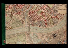
BOOTH/E/2/5-Coloured Map Descriptive of London Poverty 1898-1899 Sheet 20 - Stroud Green, Ferme Park, Finsbury Park
BOOTH/E/2/5-Coloured Map Descriptive of London Poverty 1898-1899 Sheet 20 - Stroud Green, Ferme Park, Finsbury Park
BOOTH/E/2/7-Hand Coloured Map Descriptive of London Poverty 1898-1899 Sheet 22 - Walthamstow Marshes
BOOTH/E/2/7-Hand Coloured Map Descriptive of London Poverty 1898-1899 Sheet 22 - Walthamstow Marshes
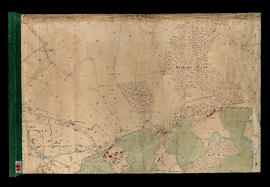
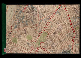
BOOTH/E/2/9-Hand Coloured Map Descriptive of London Poverty 1898-1899 Sheet 27 - Hampstead Heath, Rosslyn Park
BOOTH/E/2/9-Hand Coloured Map Descriptive of London Poverty 1898-1899 Sheet 27 - Hampstead Heath, Rosslyn Park
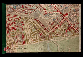
BOOTH/E/2/10-Hand Coloured Map Descriptive of London Poverty 1898-1899 Sheet 28 - Parliament Hill, Dartmouth Park, Upper Holloway, [Gospel Oak], Tufnell Park
BOOTH/E/2/10-Hand Coloured Map Descriptive of London Poverty 1898-1899 Sheet 28 - Parliament Hill, Dartmouth Park, Upper Holloway, [Gospel Oak], Tufnell Park
BOOTH/E/2/26-Hand Coloured Map Descriptive of London Poverty 1898-1899 Sheet 53 - West Ham, Mill Meads, Bromley, Bow
BOOTH/E/2/26-Hand Coloured Map Descriptive of London Poverty 1898-1899 Sheet 53 - West Ham, Mill Meads, Bromley, Bow
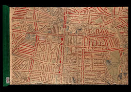
BOOTH/E/2/27-Hand Coloured Map Descriptive of London Poverty 1898-1899 Sheet 59 - Notting Hill, St Quintin Park, North Kensington, Westbourne Green
BOOTH/E/2/27-Hand Coloured Map Descriptive of London Poverty 1898-1899 Sheet 59 - Notting Hill, St Quintin Park, North Kensington, Westbourne Green
BOOTH/E/2/35-Hand Coloured Map Descriptive of London Poverty 1898-1899 Sheet 74 - Kensington, Hyde Park, Kensington Gardens, [Knight's Bridge]
BOOTH/E/2/35-Hand Coloured Map Descriptive of London Poverty 1898-1899 Sheet 74 - Kensington, Hyde Park, Kensington Gardens, [Knight's Bridge]
BOOTH/E/2/39-Hand Coloured Map Descriptive of London Poverty 1898-1899 Sheet 78 - Rotherhithe, Southwark, Isle of Dogs (part)
BOOTH/E/2/39-Hand Coloured Map Descriptive of London Poverty 1898-1899 Sheet 78 - Rotherhithe, Southwark, Isle of Dogs (part)
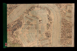
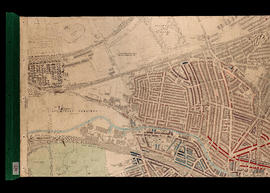
BOOTH/E/2/47-Hand Coloured Map Descriptive of London Poverty 1898-1899 Sheet 92 - Millwall, Greenwich, Maze Hill
BOOTH/E/2/47-Hand Coloured Map Descriptive of London Poverty 1898-1899 Sheet 92 - Millwall, Greenwich, Maze Hill
BOOTH/E/2/49-Hand Coloured Map Descriptive of London Poverty 1898-1899 Sheet 100 - Fulham, Sands End, Battersea, Battersea Park (part)
BOOTH/E/2/49-Hand Coloured Map Descriptive of London Poverty 1898-1899 Sheet 100 - Fulham, Sands End, Battersea, Battersea Park (part)
BOOTH/E/2/51-Hand Coloured Map Descriptive of London Poverty 1898-1899 Sheet 102 - Stockwell, Angell Town, Myatts Fields, Camberwell
BOOTH/E/2/51-Hand Coloured Map Descriptive of London Poverty 1898-1899 Sheet 102 - Stockwell, Angell Town, Myatts Fields, Camberwell
BOOTH/E/2/54-Hand Coloured Map Descriptive of London Poverty 1898-1899 Sheet 105 - Blackheath, Greenwich Park
BOOTH/E/2/54-Hand Coloured Map Descriptive of London Poverty 1898-1899 Sheet 105 - Blackheath, Greenwich Park
BOOTH/A - Papers of Charles Booth's survey of London
BOOTH/A - Papers of Charles Booth's survey of London
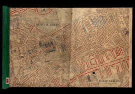
BOOTH/A/33-Papers relating to Religious Influences: Outer East London District 10 [Bethnal Green East]; District 11 [Poplar and Limehouse]; District 12 [Bow and Bromley]
BOOTH/A/33-Papers relating to Religious Influences: Outer East London District 10 [Bethnal Green East]; District 11 [Poplar and Limehouse]; District 12 [Bow and Bromley]
BOOTH/A/34-Papers concerning Religious Influences: Outer East London District 11 [Poplar and Limehouse]; District 12 [Bow and Bromley]
BOOTH/A/34-Papers concerning Religious Influences: Outer East London District 11 [Poplar and Limehouse]; District 12 [Bow and Bromley]
BOOTH/A/36-Religious Influences: North London District 14 [West Hackney and South East Islington]; District 15 [South West Islington]; District 16 [Highbury; Stoke Newington; Stamford Hill]; District 17 [Upper Holloway]
BOOTH/A/36-Religious Influences: North London District 14 [West Hackney and South East Islington]; District 15 [South West Islington]; District 16 [Highbury; Stoke Newington; Stamford Hill]; District 17 [Upper Holloway]
BOOTH/A/37-Religious Influences: North London. District 14 [West Hackney and South East Islington]; District 15 [South West Islington]; District 16 [Highbury; Stoke Newington; Stamford Hill]; District 17 [Upper Holloway]
BOOTH/A/37-Religious Influences: North London. District 14 [West Hackney and South East Islington]; District 15 [South West Islington]; District 16 [Highbury; Stoke Newington; Stamford Hill]; District 17 [Upper Holloway]
BOOTH/A/39-Religious Influences: Whitechapel; St George-in-the-East; Bethnal Green; Haggerston and part of Shoreditch District 7 [Mile End Old Town and Spitalfields]; District 8 [Aldgate; St George's in the East; Shadwell] and District 9 [Bethnal Green; North and South]
BOOTH/A/39-Religious Influences: Whitechapel; St George-in-the-East; Bethnal Green; Haggerston and part of Shoreditch District 7 [Mile End Old Town and Spitalfields]; District 8 [Aldgate; St George's in the East; Shadwell] and District 9 [Bethnal Green; North and South]
Results 57 to 84 of 867